Titan’s Sikun Labyrinthus is a an area of connected valleys and ridges that bears a certain similarity to features on Earth. The area appears analogous to what we call ‘karst topography,’ created on our planet when layers of bedrock are dissolved by water, to leave rock outcroppings and sinkholes. The Darai Hills of Papua New Guinea are an example, as are the White Canyon of Utah and the Cockpit Country of Jamaica. Liquid methane and ethane may be what is producing such landscapes on Titan, but the processes seem familiar indeed.
Which brings us to Mike Malaska, without whose insights we might not be talking about this. Malaska is an organic chemist out of Chapel Hill NC who approached Jani Radebaugh (Brigham Young University) about a potential collaboration regarding Titan. Malaska works with visualizing NASA data and shares his results with contributors on unmannedspaceflight.com, where amateur astronomers and space exploration enthusiasts regularly discuss the latest findings. The beauty of today’s world is that rich data sets become available to the public in short order, allowing for contributions from unexpected quarters.
It was Malaska’s work tracing out landscape patterns on his computer that led to the obvious question: If many of these valleys had no apparent outlets, where had the fluid that had shaped them gone? Closed valleys turn out to be typical of karst topography, as Malaska found when he examined imagery of places like Guangxi Province in China by studying imagery from Google Earth. This is top-notch work — Malaska used a color palette derived from Cassini’s imaging science subsystem as well as the descent imaging and spectral radiometer on the Huygens probe, which touched down on Titan’s surface.
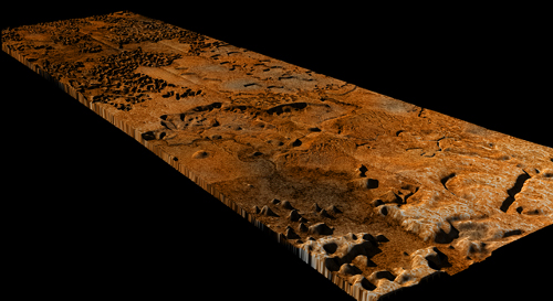
The results are striking, as shown in the image below:
Image: This artistic interpretation of the Sikun Labyrinthus area on Saturn’s moon Titan is based on radar and imaging data from NASA’s Cassini spacecraft and the descent imaging and spectral radiometer on the European Space Agency’s Huygens probe. The relative elevations are speculative and organized around the assumption that fluids are flowing downhill. Image credit: NASA/JPL/ESA/SSI and M. Malaska/B. Jonsson.
Laying a radar image over an inferred topography allowed the researchers to construct a 3D map, shown in this JPL video. We see a landscape that does bear a bit of similarity to Utah, and puts me in mind of some of John Ford’s westerns, which were often shot amidst spectacular rock outcroppings in that state. Sikun Labyrinthus inescapably reminds us of our own world, as Cassini radar team associate Karl Mitchell (JPL) points out:
“Even though Titan is an alien world with much lower temperatures, we keep learning how many similarities there are to Earth. The karst-like landscape suggests there is a lot happening right now under the surface that we can’t see.”
Caves perhaps? It will be a while before we know. Meanwhile, what an example for amateur planetary scientists. Malaska met Radebaugh at last year’s Lunar and Planetary Science Conference and went on to push his fascination with Cassini’s Titan imagery to its logical limit. Just as amateur astronomers are now making serious contributions by measuring exoplanet transits, so the much closer to home task of in-system investigation has taken on a public dimension through widely distributed data.


Hi Paul
Reminds me of the opening sequence on Titan in Stanislaw Lem’s “Fiasco”, a weird landscape of semi-organic shapes, all formed by cryovolcanism and erosion. A good book for reminding one of the dangers of our assumptions about how ETIs must behave.
Yes, Lem’s books all seem to work on our assumptions in interesting ways!
Thanks for posting this!
Here is link to the full fly through sequence (20 seconds) for Sikun Labyrinthus including a travelogue:
http://www.flickr.com/photos/31678681@N07/4413738157/
Hi Folks;
Wouldn’t it be neat if cryogenic life forms some how developed on Titan. They would likely be very simple, but I am reminded of the possibility of cryogenic chemistry and significant phase changes that can occur such as the onset of superconductivity at low temperatures.
I am curious about the possibility that superconductivity phase changes, and cryogenic superconductivity in general, may have some bearing on the development of cryogenic temperature based lifeforms.
The fact that the number of qualitatively different thermodynamic degrees of freedom on Titan seems larger than it might otherwise be as evidenced by the rich chemistry and geological features on Titan may provide for some odd forms of life to develop.
Our current ability to send planetary probes all over the solar system is impressive, and to do such with ordinary chemical rockets is also impressive. This is just a sign of what dreams will come, except that the dreams I hope and believe will become reality.
How much would it cost to send a manned mission to Titan? Could it be possible to do so in full cooperation with the Nordic Countries and with Iceland? I feel Titan looks exactly like Iceland when I explore it´s images!
On the cost of a manned mission to Titan, this article may help:
https://centauri-dreams.org/?p=12778
I’ve traveled often in Iceland and love the country, but Titan would be a good bit colder!
I have my own views on how hot or cold it may be on Titan. My primary concern is regulation to make sure Titan will not be abused like my country. My secondary concern , is the difficulties in building up the unmanned space craft itself. That requires sending space shuttles out into Earth´s orbit , where the astronauts will litterally have to put the spacecraft together.
Then I began to think and see before myself what kind of spacecraft I´m talking about – that´s a seriously difficult and challenging task.
I figure that we can have four sattellites on board the spacecraft. One sattellite maps out Titan´s entire surface , the other sattellite researches volcanic activity , while the third sattellite researches potential earthquake activity.
The fourth sattellite is the coolest one of them all. It carries a submarine which can be sent into one of Titan´s lakes to map the lake´s bottom and explore it´s features. If earthlike conditions are discovered – we have to tighten regulations to make it nearly impossible for oil companies and related investors to compete over potential , future Titan missions. It amazes me that perhaps as of 2098 , when I envisiage the completion of the mission there may already have been a trip to the Neptunean system.
I already put a name on the spacecraft a few days ago and made a small , miniature drawing yesterday night.
I have already told NASA that I have no problem with passing away before the mission is completed (presumeably from old age or some other temporary state of being) because we live such short lives on the surface of this beautiful , blue planet. Everything having to do with Titan is big , and Titan is changing my perspective on things , yet , Titan is just one of so many other worlds out there. Once the craft has been parked , all that´s needed to be done is waiting for a mission where the craft is retrieved and brought back to Earth. Such a mission might be completed as of sometime prior to 2124.
I began to read the article and I guess I have to read the whole book and I have no problem reading books that thick. Despite I have often sent awkward comments in the past on mine and some other blogs , I don´t have to do that here and I keep doing all the best to improve my skills.
warm regards,