How to make sense of Enceladus? The moon’s famous jets of water vapor, mixing with organic compounds, salts and silica, first revealed the possibility of an ocean beneath the icy surface, and the Cassini orbiter has treated Enceladus as a high priority target ever since. But why the asymmetry here? After all, while the south polar region includes the active ‘tiger stripe’ fractures associated with the plumes in a geologically young area, the northern pole shows much more cratering, evidence for a considerably older surface and, obviously, no plumes at all.
Perhaps, say astronomers from NASA, the University of Texas and Cornell, we’re dealing with an ancient impact, one that completely re-oriented Enceladus by tipping it about 55 degrees away from its original axis. Thus we get fractures well over 100 kilometers long in the south, evidence for an asteroid strike in what would have once been an area close to the moon’s equator. Radwan Tajeddine (Cornell University) is a Cassini imaging team associate and lead author of the paper on this work, which recently appeared online in Icarus:
“The geological activity in this terrain is unlikely to have been initiated by internal processes,” says Tajeddine. “We think that, in order to drive such a large reorientation of the moon, it’s possible that an impact was behind the formation of this anomalous terrain.”
Giving weight to the hypothesis is the presence of a series of basins that can be detected across Enceladus’ surface. The researchers believe these are traces of a previous equator and poles. The features visible to Cassini would also reflect underlying variations in the ice shell. Such an impact would have caused Enceladus to wobble, finally re-establishing stability over the course of at least a million years. The alteration to the north-south axis resulting from this is known as ‘true polar wander,’ changing the locations of north and south poles.
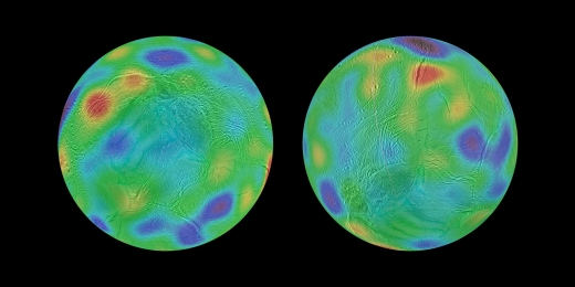
Image: These maps look toward the icy moon’s southern hemisphere, with colors representing highs and lows. Purple represents the lowest elevations, while red represents the highest. The map at left shows the surface of Enceladus in its possible ancient orientation, millions of years ago. The chain of basins representing topographic lows can be seen in blue and purple, running along the equator, with an additional low region around the original south pole. The region that encloses the moon’s currently active south polar terrain, with its long, linear “tiger stripe” fractures, would have been at middle latitudes just south of the equator. The map at right shows the current orientation of Enceladus. Credit: NASA/JPL-Caltech/Space Science Institute/Cornell University.
Thus if we simply re-orient Enceladus by about 55 degrees of latitude, the pair of depressions found by the researchers lines up with a much older equator and poles. And we have an explanation for the existence of the ‘tiger stripe’ fractures and their jets. An Enceladus without jets would have been visually less dramatic, but the impact theory also reminds us that other moons without telltale geysering activity may conceal internal oceans of their own.
The paper is Tajeddine et al., “True polar wander of Enceladus from topographic data,” published online by Icarus 30 April 2017 (abstract).

True Polar Wander,TPW , is a feature of many solar system bodies .( including Earth) . It can be caused by intrinsic causes ( such as convection into the crust from beneath by either magma, diapirism ( warm ice) or even water ( subterranean oceans ) . Alternatively , extrinsic causes including ” impactors “. This last theory for Enceladus is speculative and as such left to the conclusion of the article as a potential explanation ( email correspondence with author) . That said, a proposed TPW of 55 degrees extrapolating back would put the current south polar terrain at the leading edge of Enceladus ‘ orbit around Saturn and thus most vulnerable to an impact. Unusually however , Enceladus is the only Saturnisn moon without evidence of a major impact basin and it may be that the tiger stripes are an alternate topographic manifestation of such an event. (A beneficial one though in allowing geyser formation from the underlying tidally created ocean. ) This also fits with the conventional north polar terrain which would originally been situated at the moon’s trailing edge. If so, it likely occurred millions of years ago given TPW is a slow event . Even via an impact , which doesn’t so much as knock the moon into a new axis as altering the distribution of mass ( and moment of inertia ) in what is an otherwise spherical body . This over time leads to a change of axis to align with it.
http://astrobiology.com/2017/09/ground-based-detection-of-a-cloud-of-methanol-from-enceladus-when-is-a-biomarker-not-a-biomarker.html
Ground-based Detection of a Cloud of Methanol from Enceladus: When is a Biomarker Not a Biomarker?
Source: astro-ph.EP
Posted September 27, 2017 11:54 PM
Saturn’s moon Enceladus has vents emerging from a sub-surface ocean, offering unique probes into the liquid environment. These vents drain into the larger neutral torus in orbit around Saturn.
We present a methanol (CH3OH) detection observed with IRAM 30-m from 2008 along the line-of-sight through Saturn’s E-ring. Additionally, we also present supporting observations from the Herschel public archive of water (ortho-H2O; 1669.9 GHz) from 2012 at a similar elongation and line-of-sight. The CH3OH 5(1,1)-4(1,1) transition was detected at 5.9 sigma confidence. The line has 0.43 km/s width and is offset by +8.1 km/s in the moon’s reference frame.
Radiative transfer models allow for gas cloud dimensions from 1750 km up to the telescope beam diameter ~73000 km. Taking into account the CH3OH lifetime against solar photodissociation and the redshifted line velocity, there are two possible explanations for the CH3OH emission: methanol is primarily a secondary product of chemical interactions within the neutral torus that (1) spreads outward throughout the E-ring or (2) originates from a compact, confined gas cloud lagging Enceladus by several km/s. We find either scenario to be consistent with significant redshifted H2O emission (4 sigma) measured from the Herschel public archive. The measured CH3OH:H2O abundance (> 0.5 per cent) significantly exceeds the observed abundance in the direct vicinity of the vents (~0.01 per cent), suggesting CH3OH is likely chemically processed within the gas cloud with methane (CH4) as its parent species.
E. Drabek-Maunder, J. Greaves, H. J. Fraser, D. L. Clements, L.-N. Alconcel
(Submitted on 27 Sep 2017)
Comments: 16 pages, 4 figures, accepted for publication in the International Journal of Astrobiology (IJA)
Subjects: Earth and Planetary Astrophysics (astro-ph.EP)
Cite as: arXiv:1709.09638 [astro-ph.EP] (or arXiv:1709.09638v1 [astro-ph.EP] for this version)
Submission history
From: Emily Drabek-Maunder
[v1] Wed, 27 Sep 2017 17:21:12 GMT (1879kb,D)
https://arxiv.org/abs/1709.09638